
Some places earn their reputation quietly, through word of mouth passed between serious travelers who understand that the best outdoor experiences rarely appear on the first page of any search result. Others carry a fame so thoroughly deserved that even jaded adventurers arrive and find themselves genuinely speechless. What the five campsites collected here share is a quality that photographs only partially capture and descriptions never fully convey: the specific feeling of being exactly where the natural world is doing something extraordinary, and being small enough within it to appreciate how extraordinary that actually is. Each location faces pressures that make the window for experiencing them in their current state genuinely finite. Climate shifts, access policy changes, increasing visitor pressure, and conservation-driven permit restrictions are all actively reshaping what these places look like and how accessible they remain. The 2027 framing is not an arbitrary urgency manufactured to drive clicks. It reflects real, documented timelines attached to each location that make visiting sooner meaningfully different from visiting later. What follows are five specific, detailed reasons to plan now rather than continue adding destinations to a list that the calendar has already started working against.
1. Trolltunga Camping Plateau, Hardangerfjord, Norway
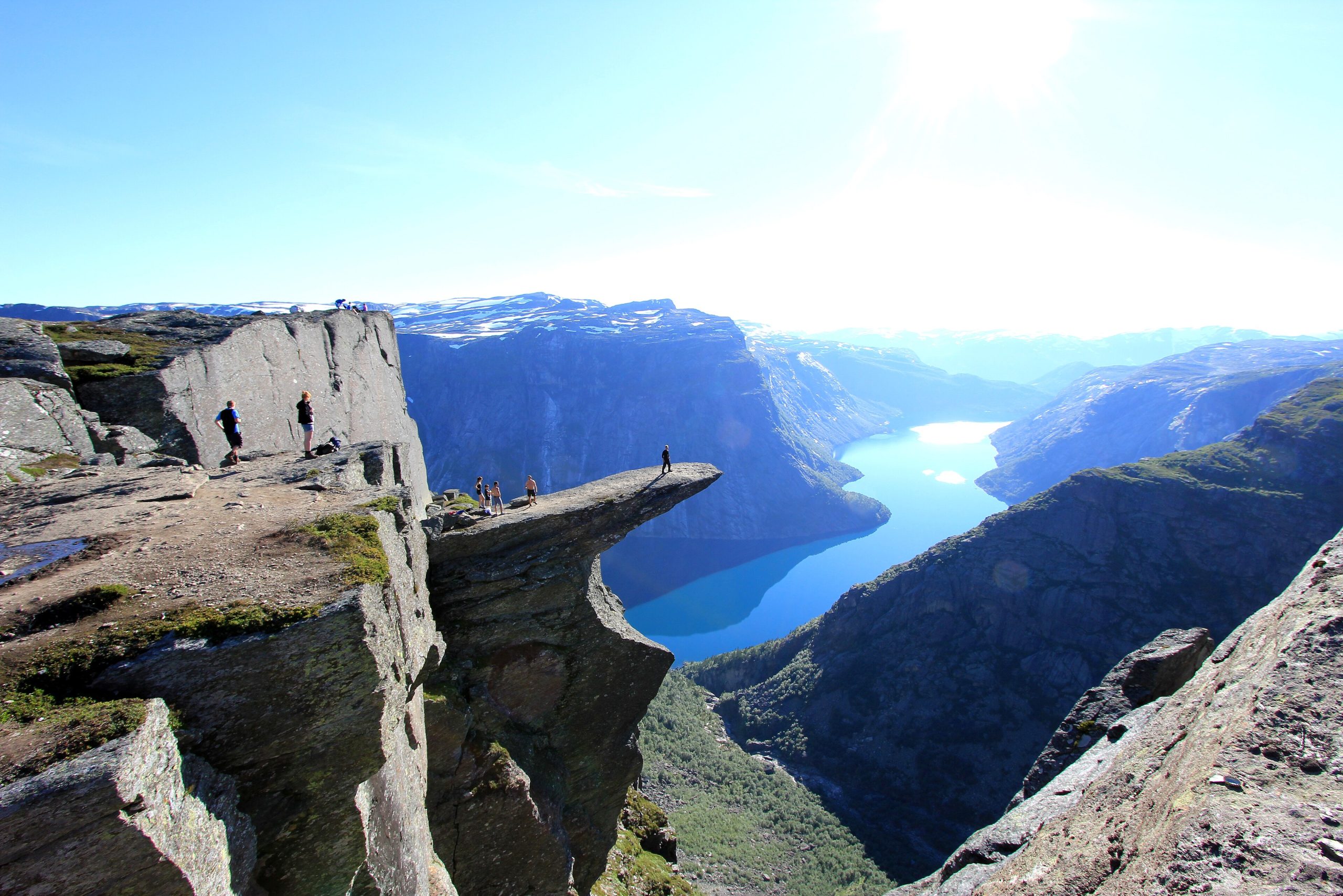
Trolltunga, the iconic horizontal rock tongue jutting 700 meters above Lake Ringedalsvatnet in Vestland county, draws approximately 80,000 visitors annually, but the small plateau immediately behind the formation permits wild camping that transforms the experience entirely. Arriving at the plateau between 6 PM and 8 PM after most day hikers have turned back places you at one of the most photographed geological formations in Scandinavia in near-complete solitude as alpenglow turns the surrounding fjord landscape amber and violet. The round-trip trail from Skjeggedal covers 27 kilometers with 800 meters of elevation gain, typically requiring 8 to 12 hours for average hikers. Norwegian allemannsretten, the right to roam law, permits wild camping anywhere in natural areas for up to 2 nights without permission, making this legally straightforward for international visitors. Average overnight temperatures in peak season from June through August sit between 5 and 12 degrees Celsius at the plateau elevation of approximately 1,100 meters. Norwegian Scenic Routes administration has signaled infrastructure development plans for the Hardangerfjord corridor through 2027 that will change access patterns and potentially introduce formal camping restrictions that currently do not exist.
2. Coyote Buttes North Permit Zone, Paria Canyon, Arizona and Utah
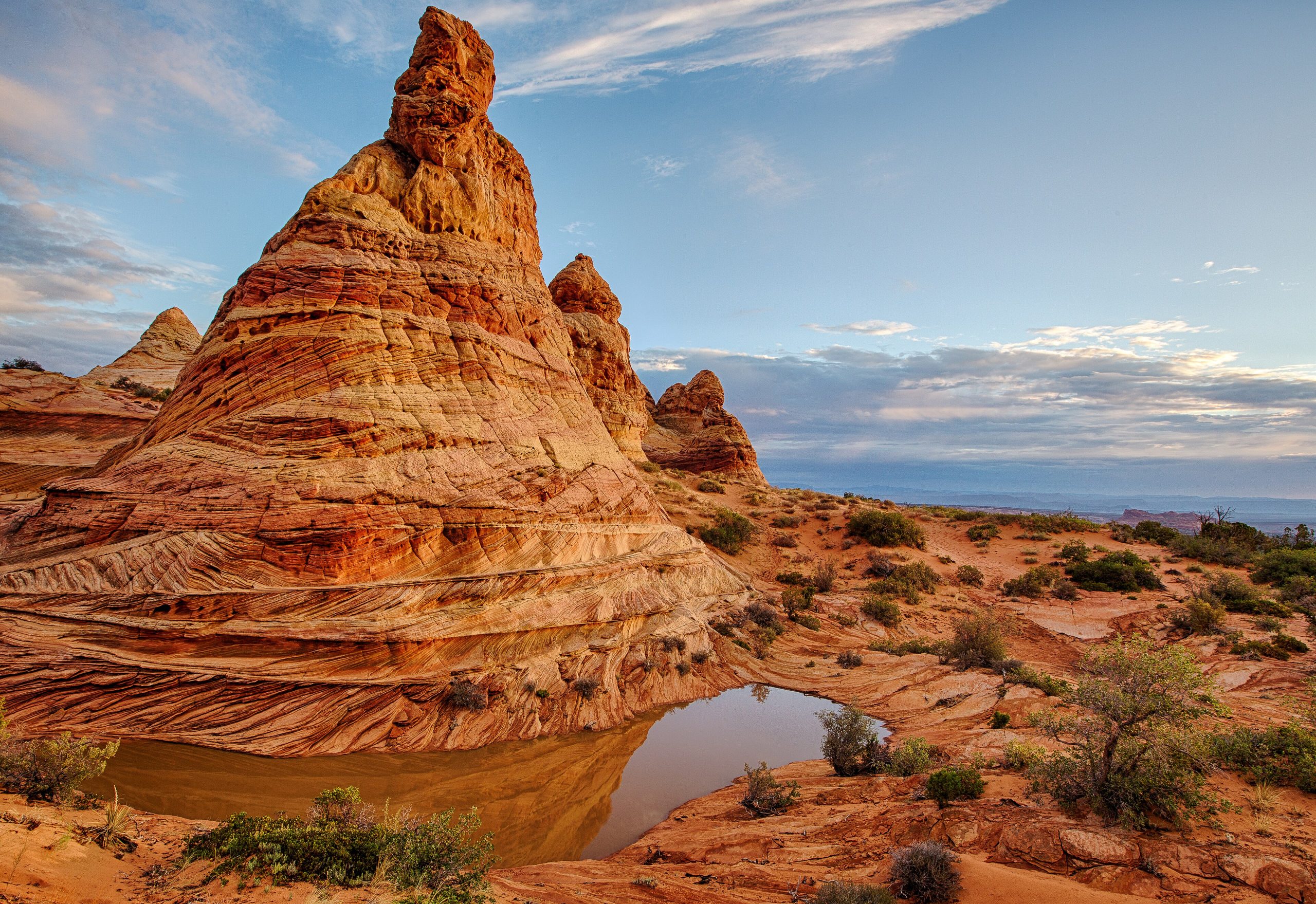
The Wave formation within Coyote Buttes North is arguably the most visually surreal sandstone landscape accessible by foot anywhere in North America, a flowing confluence of cross-bedded Navajo sandstone in coral, cream, and rust tones that looks more like a frozen ocean than solid rock. The Bureau of Land Management issues exactly 64 permits daily, split between 48 awarded through an online lottery 4 months in advance and 16 through an in-person lottery the day before entry. Daily permit demand routinely exceeds 1,000 applicants for those 64 slots, making planning essential rather than optional. The 6.4-kilometer round-trip hike from the Wire Pass trailhead requires navigating by GPS coordinate rather than marked trail, with the formation sitting at approximately 1,490 meters elevation in a permit zone covering 5.5 square miles of unmarked canyon terrain. Summer temperatures regularly exceed 40 degrees Celsius on exposed sandstone surfaces, making March through May and September through November the practical visiting window. BLM management plans currently under review include proposals to reduce daily permit numbers by up to 30 percent by 2026 in response to documented surface erosion on the sandstone formations from foot traffic concentration.
3. Rinjani Summit Crater Rim Camp, Lombok, Indonesia
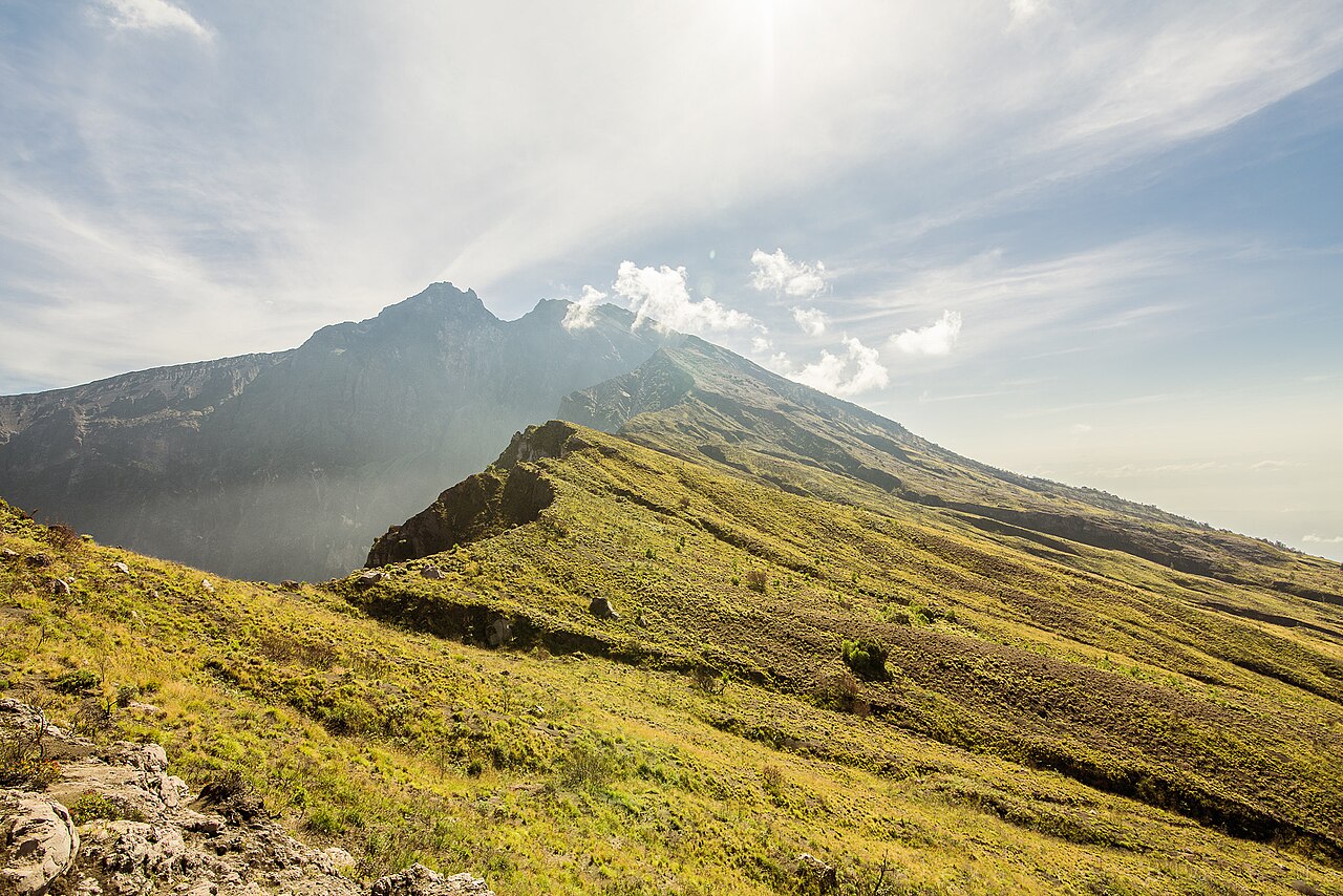
Mount Rinjani’s crater rim at 3,726 meters elevation hosts one of the most dramatic overnight camping experiences available anywhere in Southeast Asia, combining active volcanic landscape, a turquoise crater lake called Segara Anak sitting 600 meters below the rim, and unobstructed views across Lombok, Bali, Sumbawa, and on clear nights the lights of ships crossing the Lombok Strait. The standard trekking route from Sembalun village covers approximately 17 kilometers to the rim with 2,400 meters of elevation gain over 2 days, with camping on the rim’s exposed ridge at elevations where overnight temperatures drop to between 2 and 8 degrees Celsius, regardless of the tropical latitude. The Indonesian Ministry of Environment and Forestry implemented new trekking permit quotas in 2023, capping daily visitor numbers at 150 across all route entries combined, down from effectively unmanaged access that previously allowed upward of 600 daily trekkers during peak season. Post-eruption trail damage from the 2018 Lombok earthquake sequence remains partially unrepaired on certain descent routes. Geological monitoring reports from the Center for Volcanology and Geological Hazard Mitigation indicate elevated seismic activity beneath Rinjani’s magma chamber through 2026 that may trigger further access modifications.
4. Makgadikgadi Pans Wild Camp, Botswana
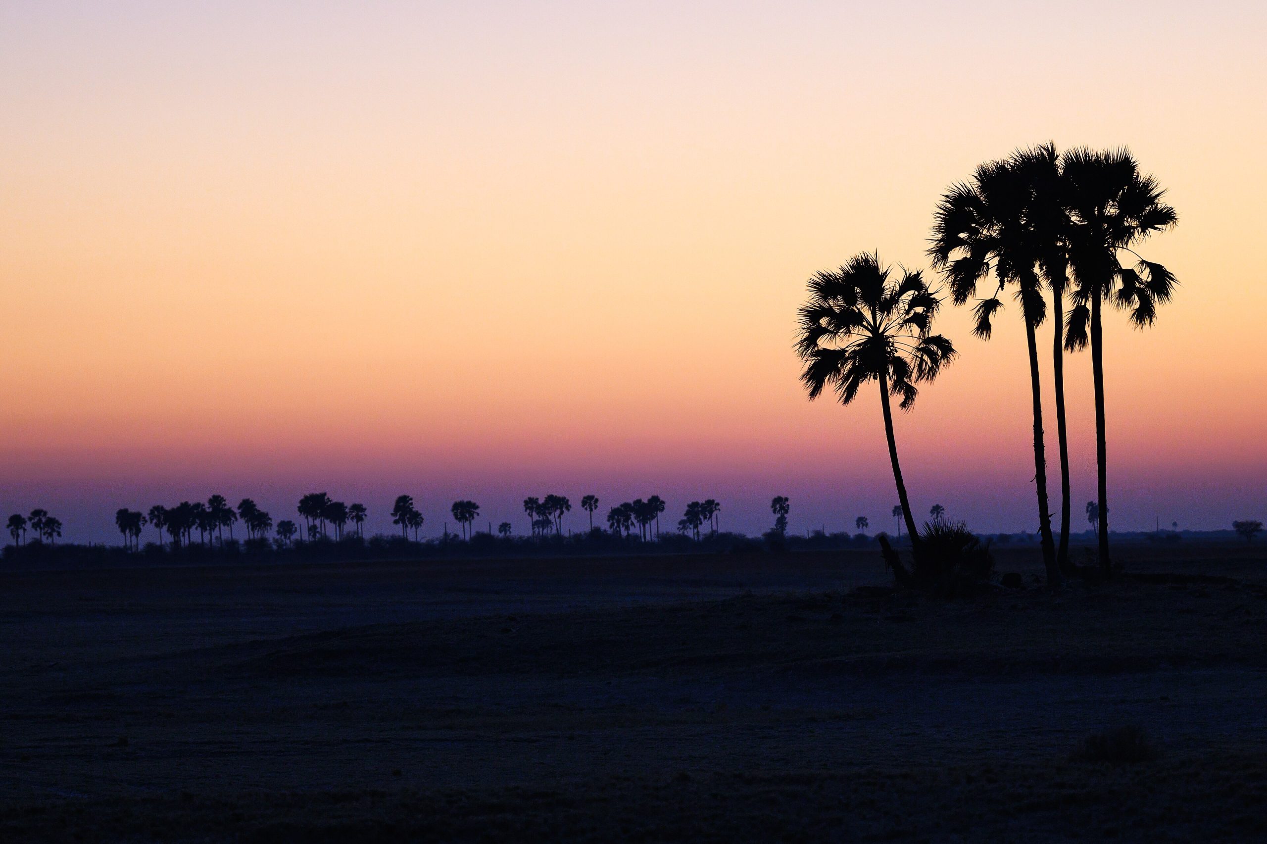
The Makgadikgadi Pans constitute one of the largest salt flat systems on earth, covering approximately 12,000 square kilometers of the central Kalahari basin in northeastern Botswana and producing a landscape so flat and reflective that the horizon becomes genuinely indistinguishable from the sky during both dawn and dusk lighting. During the dry season from May through October, the pans solidify sufficiently for vehicle and foot access across their surface, and wild camping directly on the pan floor places you in a sensory environment where the silence registers at measurable decibel levels below ambient noise recorded in most wilderness areas globally. The Makgadikgadi and Nxai Pan National Park system surrounding the open pans covers 7,500 square kilometers and requires a licensed guide for overnight pan access, with daily park fees running approximately 120 USD per person. Full moon nights on the pan surface, when reflected lunar light creates the illusion of floating above a silver plane, represent one of the most widely cited transformative outdoor experiences among travelers who have completed the visit. Botswana’s tourism ministry announced in late 2024 a revised conservation levy structure taking effect in 2026 that will increase overnight access costs by an estimated 35 to 45 percent and introduce new permit caps for pan surface camping.
5. Paine Circuit Wild Camps, Torres del Paine, Chilean Patagonia
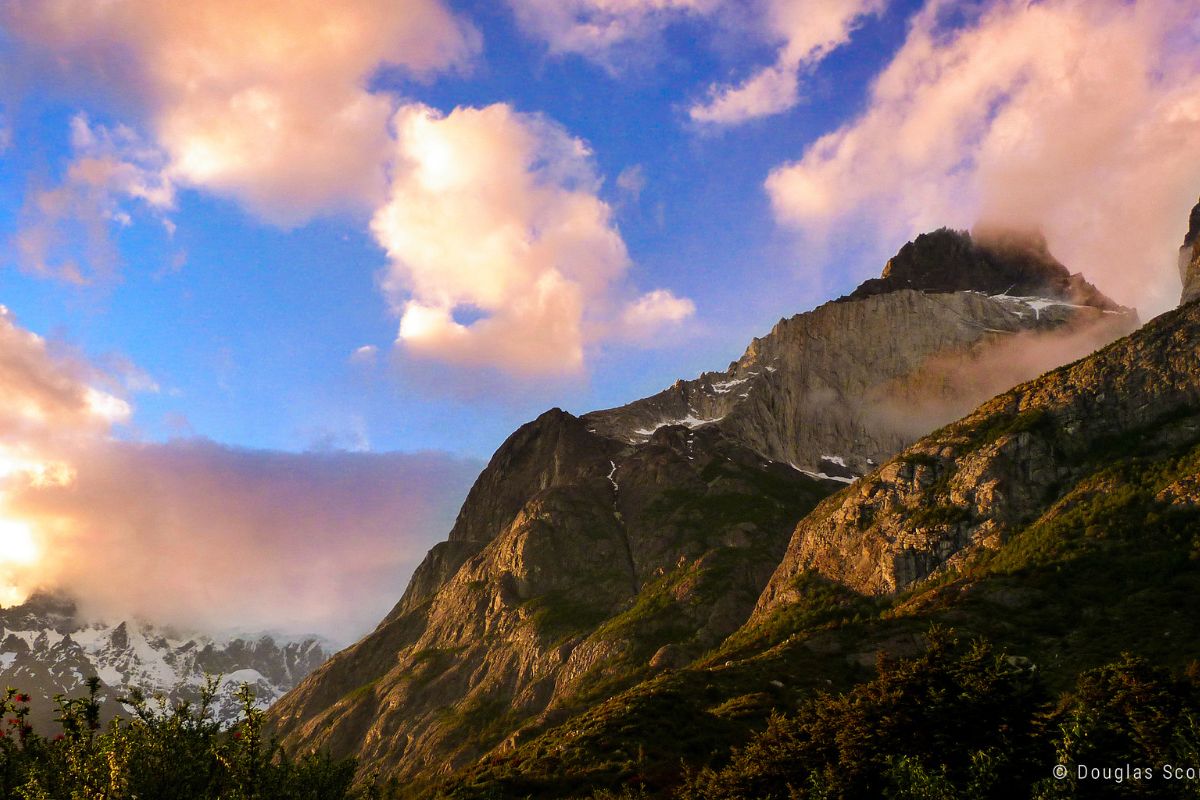
The full O Circuit around Torres del Paine massif in Chilean Patagonia covers approximately 130 kilometers over 8 to 10 days and accesses the park’s remote western and northern faces through terrain that the far more commonly completed W Trek never reaches. The backcountry camps on the circuit’s western section, including Campamento Los Perros at 390 meters and Campamento Jauncito on the glacier approach, place trekkers within direct visual range of hanging glaciers descending from the Southern Patagonian Ice Field, the third largest freshwater ice reserve on earth after Antarctica and Greenland. Average daily wind speeds on exposed sections of the circuit regularly reach 80 to 100 kilometers per hour, which is considered moderate by Patagonian standards. CONAF, the Chilean national parks authority, implemented mandatory pre-registration and campsite reservation for all backcountry circuits in 2022, with daily campsite capacity caps ranging from 40 to 80 persons per site, depending on location. Glacier recession rates on the Grey Glacier, the circuit’s most dramatic ice feature, are currently measured at approximately 5 meters of frontal retreat annually, with glaciologists projecting visible changes to the glacier’s calving face by 2027 that will meaningfully alter the landscape the western circuit currently delivers.


